


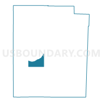
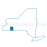
Voting District 160002, Allegany County, New York
About
Outline

Summary
| Unique Area Identifier | 624613 |
| Name | Voting District 160002 |
| County | Allegany County |
| State | New York |
| Area (square miles) | 16.26 |
| Land Area (square miles) | 16.26 |
| Water Area (square miles) | 0.00 |
| % of Land Area | 100.00 |
| % of Water Area | 0.00 |
| Latitude of the Internal Point | 42.19478730 |
| Longtitude of the Internal Point | -78.12328810 |
Maps

Graphs
Select a template below for downloading or customizing gragh for Voting District 160002, Allegany County, New York


Neighbors
Neighoring Voting District (by Name) Neighboring Voting District on the Map
- Voting District 050001, Allegany County, NY
- Voting District 140001, Allegany County, NY
- Voting District 150002, Allegany County, NY
- Voting District 160001, Allegany County, NY
- Voting District 240001, Allegany County, NY
- Voting District 290001, Allegany County, NY
Top 10 Neighboring County Subdivision (by Population) Neighboring County Subdivision on the Map
- Cuba town, Allegany County, NY (3,243)
- Amity town, Allegany County, NY (2,308)
- Friendship town, Allegany County, NY (2,004)
- Scio town, Allegany County, NY (1,833)
- Clarksville town, Allegany County, NY (1,161)
- Wirt town, Allegany County, NY (1,111)
Top 10 Neighboring Place (by Population) Neighboring Place on the Map
Top 10 Neighboring Unified School District (by Population) Neighboring Unified School District on the Map
- Bolivar-Richburg Central School District, NY (4,547)
- Genesee Valley Central School District at Angelica-Belmont, NY (4,036)
- Scio Central School District, NY (2,330)
- Friendship Central School District, NY (2,181)